A diver explores the coral reefs around Lord Howe Island. Located in the Tasman Sea between Australia and New Zealand, this volcanic island has more than 60 dive sites, including pyramid island in Burr, the world's highest sea ridge.
Photo by MELISSA FINDLEY
Our world is full of wonders, though they are sometimes hard to touch. During the pandemic, tourism has all but come to a standstill, but that hasn't dampened our enthusiasm for travel. Before the new year arrives, we hope to share the stories of these 25 Eternal Places with everyone, and let us continue to look forward to the moment when we can embark on our journey again without any scruples.
Published by National Geographic Travel, the top destinations are divided into five categories (Adventure, Culture and History, Nature, Family, Sustainability) that showcase resilient communities, innovative conservation efforts, and endless opportunities for future exploration.
The joy of travel comes from accidents. Now it's time to dream about and prepare for your next journey. Hopefully, our list of destinations for the new year will inspire you. Looking forward to meeting you in the next corner of the world!
The ultimate adventure
Adventurers flock to Alaska's remote Katmai National Park to spot brown bears; explore mountains, beaches and waterfalls on the Caribbean island of Dominica; trek through the electric blue snow kingdom of Los Glaciares National Park; and finally in Svaneti, Georgia's high-altitude region Region) ends the trek along the way.

In 1912, Nova Ruputa Volcano in Alaska's Katmai National Park and Reserve erupted, forming craters and crater lakes at the summit of Mount Katmai.
摄影:KATIE ORLINSKY, NAT GEO IMAGE COLLECTION
Katmai National Park, Alaska
Under the volcano
Katmai National Park and Reserve covers more than 20,000 square kilometers, most of which are designated as wilderness and hunting is prohibited. There are currently no roads leading here, only by boat or seaplane.
For many visitors to the park (even before the pandemic, the number of visitors was limited) Katmai is a 2-meter fishing spot and the world's largest gathering of brown bears. Thanks to the "Bear Cam" real-time video system on social media, coupled with the "Fat Bear Week" competition, this brown bear park has become famous.
To archaeologists like Laura Stelson, Katmai National Park is a place to study 9,000 years of human history. Laura Stelson came here in 1910 on an expedition sponsored by the National Geographic Society. In 1912, the Nova Ruputa volcano in the park erupted, the largest volcanic eruption of the 20th century, after which the indigenous community that has long inhabited the area was relocated and rebuilt. Stelson hopes to find the right technology to scan the pumice and other rocks that cover the park.
"Katmai is a very unique place, presenting several different types of landscapes," Stelson said. "There are coastal beaches, there are tundra, there are spruce forests, there are mountains and volcanoes, and there are weird deserts. The rich diversity of the environment can make for a lot of different experiences. ”
Wildlife lovers can swim side by side with The Dominican Sperm Whale, but reservations must be arranged by travel agents that strictly adhere to animal welfare agreements.
Photo by FRANCO BANFI, NATUREPL.COM
Dominica
Caribbean adventure tours help boost the island's climate resilience
Weathered mountains wind their way down the dormy centro, forming a natural barrier that largely protects the Eastern Caribbean island from colonial invasion and overexploitation. The local indigenous Caribbeans call the island Waitukubuli (meaning "tall and tall her"). The rest of the island is covered in lush rainforest and has natural wonders for adventure seekers: 9 active volcanoes, 365 rivers, towering waterfalls, black sandy beaches, and scorching geothermal features such as boiling lake, a stomata fountain with a water temperature of nearly 93.3°C.
Even Dominica's powerful volcanic terrain cannot stop global climate change, and the impact of hurricanes is increasing. The warm oceanic climate gave super impetus to Hurricane Maria, who swept across the island in September 2017, causing catastrophic landslides and severe damage to almost all man-made buildings.
After the hurricane, nature recovered, residents began to rebuild, and the government was determined to make Dominica the world's first climate-resilient country. This requires not only hurricane-proof buildings, but also a diversified economy, including tourism that attracts more high-end consumers, and an agricultural system that grows a variety of local fruits and vegetables. Adventure tourism plays a huge role in driving climate resilience, creating jobs, stimulating the economy and helping to restore and protect Dominica's greatest natural resources, its most pristine and wild side.
Perito Moreno glacier, located in Los Glaciares National Park in Argentina, is one of only a few glaciers in the world that is growing without shrinking. It is part of the Patagonian Ice Sheet, the world's third largest freshwater reserve.
Photo by JUERGEN SCHONNOP, EYEEM, GETTY IMAGES
Glacier National Park, Argentina
Hike in the Snow Kingdom
Nestled on the shores of the turquoise Lake Argentino, el Calafate got its name from a spiny plant whose berries add flavor to cocktails and local beers. Due to its proximity to the Argentine Glacier National Park, the town has been included in the tourist map as a gateway to the snow kingdom of southern Patagonia in Argentina.
The 4,460-square-kilometre Glacier National Park in Argentina is located near the Chilean border, and its sub-Antarctic forest provides protected habitats for moose, cougars, american ostriches, vultures, native camels and some plants. But the park is most notable for its nearly 300 glaciers, which cover almost half of the park's area. The Moreno Glacier is the most popular and easily accessible, it is 4.8 km wide and stands 60 meters above the surface of Lake Argentina. Sometimes huge ice cubes will disintegrate from its surface, making a thunderous sound, and the scene is quite spectacular. You can hike on glaciers in spikes and find patches of electric blue in waterfalls, crevasses, ice caves, underground rivers and thick layers of ice.
Argentina Glacier National Park is part of the Patagonia Ice Sheet, the third largest continental ice sheet in the world, after Antarctica and Greenland. After exploring the cold ends of the planet, visitors return to their waiting boats on the lake to celebrate their adventures with a glass of whiskey with ice cubes. —Erick Pinedo, National Geographic Traveler, Latin America
The snow-caucasus mountains surround Svaneti, home to some of Georgia's most remote villages. Many of the watchtowers in the photo were built in the Middle Ages to defend against invading armies.
Photo by PUNNAWIT SUWUTTANANUN, GETTY IMAGES
Svanieti region, Georgia
A place on the edge of hospitality
The Svaneti region is located in the Caucasus Mountains in northwestern Georgia and is surrounded by daunting mountains. The terrain is rugged and has several medieval stone towers that are both residential and fortified. The Svans fought fierce battles to seize land in small villages and high-altitude settlements like Ushguli, forts that were built at that time. One of the highest settlements in Europe, Ashaguri is almost 2,440 km above sea level and has been inscribed on unesco's World Heritage List.
Due to its remote location and isolation from the rest of Georgia, the Svan culture has developed over the centuries with unique spoken languages and traditions, such as shaving rituals and bloody conflicts. Once notorious for its lawlessness, the region is now recognized for its hospitality. Georgia is known for its hospitality, and Svanieti's hospitality is among the best in the country. MichaelŁ Głombiowski, a travel writer and photographer from Poland, said: "Svanieti's day is spent in parties, toasts and alcohol. "He often goes to Georgia.
Today, Swagnetti is still far from the inhabited, but intrepid adventurers can access through the Upper Svaneti section of the Transcaucasian Trail, a long-distance road network whose ultimate goal is to connect Georgia, Armenia and Azerbaijan. If you have enough lung capacity, try a four-day high-altitude trekking tour from the regional capital, Mestia, to Ushguli, where you can watch the mountains and feel the cool and beautiful scenery during the day and return to Svan Homestay in the evening for a warm welcome. —Martyna Szczepanik, National Geographic Traveler, Poland
Discover cultural and historical sites
If you're in Tulsa, Oklahoma, face up to the history of racial discrimination and help them build a better future. You can also celebrate the resilience of the local indigenous people in the Pueblo tribe of New Mexico; go to Guam to reminisce about the legendary feats of Magellan 500 years ago; visit Gyeongju, South Korea to admire the relics of the Golden Age; experience the joy of cultural convergence in Victoria, Spain;and experience the Land Art Festival in Tonglu County, Zhejiang, China.
In June 2018, shortly after the unveiling of the "Black Wall Street Mural," people gathered in Tulsa's Greenwood District. Racial violence has destroyed this once-thriving black business district, and a cultural and economic renaissance is underway.
Photo by SHANE BEVEL
Tulsa, Oklahoma
A center of discussion on race in the United States
Tulsa's newly formed "Black Wall Street" historic center, named "Greenwood Rising," aptly describes the wave of support for sustainable socioeconomic transformation in Oklahoma City's Greenwood District. Greenwood has experienced the worst incident of racial violence in U.S. history.
On May 31, 1921, white terrorists destroyed the bustling area in an 18-hour attack, killing about 300 black residents and leveling nearly 35 blocks of black homes and shops. To mark the 100th anniversary of the Tulsa Massacre and spread the story of this once vibrant community, the 1921 Tulsa Centenary Of Genocide Committee is actively building Greenwood Rising (scheduled to open in the fall of 2021), which will host speeches, concerts and other special events throughout the year.
The Historic Center was designed to promote a renaissance in Greenwood to combat and end systemic racism across the United States, said Phil Armstrong, program director at the Centennial Committee.
"There's a feeling now in Tulsa and across the country that we have a lot of room for improvement," Armstrong said. "Greenwood Rising continues to drive discussions about racial trauma and reconciliation, and the historic district as a whole will help people learn, acknowledge hidden biases, and make real changes within their own spheres of influence."
Taos Pueblo is the only Native American site with dual identities as a "World Heritage Site" and a "National Historic Landmark of the United States", and is one of the oldest inhabited communities in U.S. history.
Photographed by INGE Johnsson, Alamy
Pueblo, New Mexico
Voice of the Indians in the Southwestern United States
In New Mexico, as monuments to Indian oppressors were torn down (such as the Spanish conquistador Don Diego de Vargas), some activists began calling for the commemoration of Po'pay, the organizer of the Pueblo Uprising of 1680. In this uprising, the Spaniards were expelled from their homes for the Pueblo Indians. Although they returned after 12 years and regained dominance, this revolt ensured the long-term survival of the Pueblo culture.
At the U.S. Capitol Visitor Center in Washington, D.C., there is a statue of Popee, representing New Mexico. Within the United States, Pope's monumental heritage is embodied in the state's 19 Pueblo villages, including Taos Pueblo, a UNESCO World Heritage Site. Each village is a "sovereign state" and a living community with its own unique traditions. The Indian Pueblo Cultural Centre (IPCC) in Albuquerque is the starting point for exploring Pueblo culture, and you can visit online with a virtual cultural guide to see you when the pandemic is over and group tours and celebrations resume.
Michael Lucero, IPCC Customer Experience Manager and Member of the Pueblo of San Felipe, refers to the center's resources as "perspective mirrors" that allow visitors to better understand the diversity of life in Pueblo. "When you step on Pueblo, you connect the dots of information," Lucero says. "This is where we feel safe and connected to the planet."
In April 2017, on Guam, a local Chamorro dance troupe performed a blessing dance at the U.S. Naval Cemetery.
Photo by CHUCK LITTLE, ALAMY
Guam
Revisiting Magellan's legacy in the Pacific
Guam is a U.S. territory and the largest island in the Mariana Islands, and the 500th anniversary of Magellan's first circumnavigation of the globe is nothing to celebrate. In March 1521, the Portuguese explorer Magellan killed the indigenous Chamorros during his three-day stay in Guam and mistakenly labeled the Mariana Islands "Islas de los Ladrones" (Islas de los Ladrones).
A Spanish naval vessel will dock on Guam in March 2021 as part of a commemorative voyage to retrace the circumnavigation route initiated by Magellan in 1519 and completed by the Spanish navigator Juan Sebastian Elcano in 1522. For today's Chamorros, the arrival of the Anniversary Expedition is an opportunity to tell their own stories, such as the encounter with Magellan, the colonial history of Guam, and the realities of life on Guam, an important U.S. military base and the "tip of the spear" of the U.S. military in the Pacific.
Guam's complex past is well represented in Chamorro, a language influenced by Spanish, English and Japanese. More and more young Chamorro people are learning to embrace their culture, says Chamorro writer and activist Michael Bevacqua.
"Chamorro is an indigenous memory," Bevacqua added. He taught free language classes and encouraged fellow Chamorro to speak out for Guam's future political status, whether it remained stated or independent. "For me, being able to speak Chamorro and pass it on is at the heart of our culture and the identity of our people."
Gyeongju, South Korea, overlooking the tranquil waters of Yandang Pond from the site of the Rinkai-den Temple (formerly known as the East Palace).
Photograph by JOSHUA DAVENPORT, ALAMY
Gyeongju, South Korea
This ancient Korean kingdom still shines today
Gyeongju is known as the "Museum Without Walls", and this year, it was elected as the "2021 East Asian Cultural Capital" on behalf of South Korea. Located in the southeast corner of the Korean Peninsula, this ancient city is rich in archaeological sites, thanks to the nearly millennia-old rule of the ancient Silla kingdom of Joseon (57 BC to 935 AD).
The Gyeongju Historic District is home to a large collection of Buddhist art surviving from Korea's Golden Age, including temples, palace ruins, stone pagodas, stone carvings, a magnificent 8th-century Buddha statue, and about 150 tombs of Silla nobles, some up to 23 meters high. In 2000, the Gyeongju Historic District was listed as a UNESCO World Heritage Site.
In the "Golden Kingdom Silla" exhibition at the Gyeongju National Museum, gold, silver, and bronze gilded crowns, jewelry, and other shiny artifacts unearthed from the tombs are unveiled. Here you can feel the luxurious lifestyle of the Silla royal family. —Bo-yeon Lim, National Geographic Traveler, South Korea
The elegant Plaza de Espana is a central gathering point in Basque Victoria.
Photo by FRANCESCO BONINO, SHUTTERSTOCK
Victoria, Basque Country, Spain
Jazz and legend in the Basque Cultural Capital
Spain's Basque Country is rich in traditions, and the capital, Victoria, is a city with both historical heritage and modern art, which can be called the cultural pearl of Spain. Victoria's Basque name is Gasteiz, and it is located in the Middle Ages on the shortest route connecting the Kingdom of Castile with Northern Europe, and was once an important commercial and cultural hub.
Today, Victoria continues its tradition of being at home at the Victoria International Jazz Festival, which takes place every July, where both new jazz stars and legendary jazz masters feel at home. Trumpeter Winton Marsalis played the Victoria Suite as a tribute to the city. Victoria also erected a bronze statue of Marzaris in La Florida Park, a victorian green space surrounded by a large number of parks that make Victoria's per capita green space larger than any other city in Spain. Thanks to its remarkable achievements in nature conservation and its commitment to sustainable transport (a large proportion of the population travels by bicycle or tram), Victoria was awarded the title of "Green Capital of Europe" in 2012.
Victorians who advocate for the preservation of nature are equally keen on the preservation of tradition, especially in historic areas. The majestic Gothic Basilica of Santa Maria stands proudly on a hill overlooking this centuries-old area. In the streets named after the medieval artisan association, locals flock to bars and restaurants to taste pintxo (a tapas). Every August, an unusual celebration is held in the square at the southern end of the old town to commemorate the patron saint of the city. During the celebration, people gathered here to watch the puppet show, and a doll named Celedon sped down the high ropes with an umbrella to kick off the party. Upon reaching the balcony, Celedon magically transforms into a real person, encouraging people to enjoy the. —Sergi Ramis, National Geographic Traveler, Spain
For centuries, the picturesque countryside of Tonglu has been a source of inspiration for Chinese artists and writers, and the famous Yuan Dynasty painter Huang Gongwang's "Fuchun Mountain Residence Map" was created in Fuchun River in Tonglu County.
Photo by ANDY BRANDL, GETTY IMAGES
Tonglu, China
China's famous scenic spots ushered in the first art event
Fuchun Mountain Jutu is an ink painting on paper by the Yuan Dynasty painter Huang Gongwang, completed in 1350 and up to 6.7 meters long after full unfolding. The painting takes the Fuchun River in Tonglu, Zhejiang Province as the background, with light ink and elegant, and the landscape is properly arranged, depicting the early autumn scenery along the Fuchun River, bringing us a flowing visual feast.
Huang Gongwang, the head of the Yuan Four Families, lived in seclusion for three years in Tonglu on the banks of the Fuchun River before completing this masterpiece. Since then, the tranquil Tonglu has been a source of inspiration for generations of Chinese artists. Tonglu is located in eastern Zhejiang, 270 kilometers southwest of Shanghai.
In 2021, Tonglu will once again become the focus of the art world. The first Tonglu Land Art Festival was originally scheduled to be held in the autumn of 2020, every three years, but postponed to the spring of 2021 due to the epidemic, when many modern art exhibits will be exhibited on the banks of the field river, and the organizers hope to promote rural tourism. Kitagawa said the word "Kirito" is a good expression of the spirit of the event, as curator and general artistic director of the Kirito Daichi Arts Festival, who is also the founder of the Echigo Tsumari Triennial, the word "Kirito" is a good example of the spirit of the event.
"In this season, the fog on the Fuchun River intertwines with the clouds in the mountains, much like the Chinese landscape paintings I saw when I was a child," he explains. —Lu Yi, National Geographic Traveler, China
Explore fascinating wild lands
Observe wolves and moose in a national park on Royal Island, Michigan. Immerse yourself in the savannahs of Serrado, Brazil, and imagine yourself in a Jurassic Park. Stroll through Lord Howe Island, Australia, known as the "Last Paradise on Earth". See the stunning Northern Lights in Yellowknife, Canada.
In Royal Island National Park, Michigan, a female moose waded through the lake.
摄影:JIM BRANDENBURG, MINDEN PICTURES, NATIONAL GEOGRAPHIC
Royal Island, Michigan
In this lesser-known National Park in the United States, wolves and moose roam freely
On Michigan's unexplored Isle Royale, nature is wild. This is home to the most hidden national park in the northwest corner of Lake Superior. The 72-kilometer-long desert island is less than 30 kilometers off minnesota's northeastern coast, but frequent foggy banks, violent storms and rough waters make it seem so far away.
In the late 19th and early 20th centuries, several shipwrecks occurred in the dangerous waters around Royal Island, a geographical feature that shaped the island's unique ecosystem. There are 18 species of mammals in the park (compared to more than 40 native species), many of which are descendants of hardy animals, which can swim here in the summer and traverse frozen lakes in the winter.
Since 1958, scientists have been looking at The Wolf and Moose, the most famous inhabitant of Royal Island, the world's longest-consuming study of predators and prey. When there was only one pair of wolves left here in 2018, a long-simmering migration program was launched to help restore wolves, control moose populations and enhance the resilience of the entire ecosystem.
Moose are often seen in the park, and the cries of diving birds are often haunted. Humans rarely haunt here. This sense of isolation and loneliness attracts experienced backpackers and kayakers and canoe lovers who come to Royal Island with their gear to sail on paddling routes in remote areas with no way and inland lakes.
Brazil's Serado is the largest savanna in South America, home to the seven-banded armadillo and hundreds of other species.
摄影:PETE OXFORD, MINDEN PICTURES, NATGEO IMAGE COLLECTION
Serado, Brazil
This wilderness in Brazil is probably the closest thing to Jurassic Park
Brazil's Amazon region has had a lot of triumphs in terms of environmental protection, but it's not always a good thing for its lesser-known neighbor, the Cerrado Reserve. Covering nearly a quarter of Brazil's land area, the Serado grassland is the largest savanna in South America and is extremely rich in biodiversity. As soybean cultivation and cattle ranching moved out of the Amazon, deforestation is increasing. In the last decade alone, more than 100,000 square kilometers of land have been destroyed.
Brazil's "Serado Conservation Movement" ("Without grasslands, there would be no water, no life") was a wake-up call to the imminent need for rescue operations. Several major rivers in South America originate here, including the San Francisco River, the Paraguay River, the main tributary of the Paraná River, and the Aragua River, a tributary of the Tocantins River, where 5% of the earth's flora and fauna also live.
The Cerrado Reserve is unusually rich in biodiversity, including more than 10,000 species of plants (nearly half of which cannot be found elsewhere) and a variety of large creatures (like the beasts of prey in Jurassic Park): tapirs that look like wild boars weigh nearly 300 kilograms; rare large armadillos weigh up to 50 kilograms; and nearly 50 kilograms of large anteaters, which are endangered in Brazil. There is also a "big guy" in the park, a giant palm tree called buriti, which is home to more than 850 species of birds. The tree is also a major food source for many other wildlife that live here.
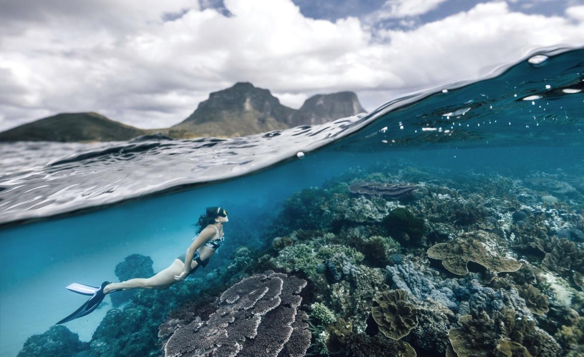
Litchfield Hill stands majestically off the lagoon of Lord Howe Island in Australia. This natural wonder has been declared a UNESCO World Heritage Site and is only allowed to 400 visitors at a time.
Photograph by PETER UNGER, GETTY IMAGES
Lord Howe Island, Australia
The "last paradise" on the Tasman Sea
Until the 18th century, Lord Howe Island in the Tasman Sea remained deserted. Today, only 400 visitors (slightly more than the resident population) are also allowed, a move that helps protect one of the most isolated ecosystems on earth, known locally as the "last paradise."
Formed during a volcanic eruption 7 million years ago, Lord Howe Island, although less than 11 kilometres long and just over 1.6 kilometres at its widest point, is the largest of the series of islands of the same name inscribed on the World Heritage List. The island is surrounded by Lord Howe Island Marine Park, home to the southernmost coral reef on Earth, more than 500 species of fish, and numerous protected and endangered marine species, including whale sharks, great white sharks and hawksbill turtles.
The island's Paradise Conservation Programme has adopted comprehensive biosecurity measures, with the help of community volunteers and related technology, to remove destructive invasive species (most recently rods) and protect endemic species such as the critically endangered Lord Howe Island stick insect, which was thought to have become extinct before 2001.
Over Yellowknife, the capital of Canada's northwestern region, the Northern Lights bloomed and staged an "electric light show".
摄影:SEONG-WON JANG, EYEEM, GETTY IMAGES
Yellowknife, Northwest Territories, Canada
It is illuminated by the Northern Lights 240 nights a year
The story of Yellowknife, the capital of Canada's Northwest Territories, is like an adventure novel. It sits on the edge of the Arctic, on the shores of Lake Danu, surrounded by wild coniferous forests. In the 1930s, gold mines were discovered here, and the city gradually formed, with a population of about 20,000.
Gold mining has been a major industry in Yellowknife for decades, and when the last local gold mine was closed in 2004, the city had turned to diamond mining: in 1991, geologists discovered one of the richest diamond deposits on Earth.
Thousands of years ago, the Diani people began to cultivate this land. Today, in the face of global challenges such as pandemics, climate change and environmental degradation, ethnic people have found freedom in this land, says Catherine Lafferty, a Writer of the Yellowknis. Her new book, Land, Water, and Sky, was the first to sign her Diani name, Katłıà.
Lafferty grew up in Yellowknife and wrote about the injustices of the Aboriginal people of northern Canada. "Going to the land is a way for us to find peace and solace in our hearts, and we can find healing in the process," she says. "Land reminds us to remember what is important. There we can find happiness in the simple gifts of nature. ”
If you're heading to Yellowknife, experience nature's bounty in the northern forests illuminated by the Northern Lights and the countless small lakes outside the city as you cruise at night. —Ondřej Formanek, National Geographic Traveler, Czech Republic
Get ready for a wonderful family trip
Learn about the cultural history of the Aboriginal people of British Columbia, Canada, that spanned 10,000 years. Explore the stars on Florida's Space Coast. Head to the England Coast Path and experience what it's like to stroll on the longest coastal walk in the world. Go to Holtobagy, Hungary to experience the local thousand-year-old nomadic culture. Find authentic idyllic life in the fantastic beauty of Transylvania, Romania.
For several Indigenous peoples on British Columbia's West Coast, the totem poles in Vancouver's Stanley Park have a wealth of significance. Each sculpture represents a true story or mythological event.
Photograph by ANDREW (CHUNGHO) KIM, ALAMY
British Columbia, Canada
Nature's connection with indigenous peoples
British Columbia, Canada's westernmost province, is home to more than 200 different ethnic groups. In global reflection on race issues, understanding British Columbia's Aboriginal people as a large ethnic group facilitates parental and child discussions about issues such as cultural misappropriation and racial stereotypes.
British Columbia's Aboriginal history spans 10,000 years, with First Nations, Inuit and Métis communities all introducing Aboriginal travel routes. For families, Vancouver and Vancouver Island are the most convenient places to learn about Aboriginal culture. Vancouver Island alone is home to more than 45 ethnic groups, and the City of Vancouver offers activities for children, such as the Talaysay Tours ' Talking Trees" walking tour in Stanley Park.
During a 90-minute forest walk, cultural ambassadors from Squamish and Shíshálh share generational knowledge to help visitors understand how the First Nations of southern British Columbia used their land for food, medicine and technology.
"We see ourselves as inseparable from the land," said Candace Campo, a co-owner of Talaysay Tours and a member of the Hishar ethnic group. She explains that there is a proverb in The Himhar language: "Nuchutmulh, meaning 'we are one,' is intimately connected to all living things."
In the Rocket Garden of the Kennedy Space Center Visitor Complex in Cape Canaveral, Florida, saturn rockets, Juno rockets and Mercury redstone rockets are displayed.
Photograph by ROBERT ORMEROD
Space Coast, Florida
Miracle launch pad in the sky and underwater
As NASA's new commercial astronaut program puts U.S. astronauts into orbit, the Atlantic coastline east of Orlando, Florida, is once again a hub for space exploration. The 116-kilometer stretch of coastline, known as the Space Coast, includes launch facilities at Cape Canaveral Air Force Base and NASA's Kennedy Space Center.
At the Kennedy Space Center Visitor Complex (open under covid-19 restrictions), visitors can watch scheduled blasts of SpaceX and the Boeing Space Shuttle, walking between giant 30-meter-high rockets. The Merritt Island National Wildlife Refuge near the Space Center is also home to another different type of giant, the hulking West Indian manatee, who likes to swim in the protected area's waters.
Florida Adventurer has launched kayak tours within the reserve. During the day, visitors can kayak to watch manatees and dolphins. In the evening (June to September or later), the reserve's Indian River Lagoon will stage a unique "bioluminescent" underwater show featuring billions of glowing plankton.
"On a bioluminescent tour, kids see light refracting underwater in all directions," says Josh Myers, head of Florida Adventurers Tours. "During the day, manatees would suddenly appear next to their kayaks and spray water at them. Moments like these are sure to change children's lives and inspire them to learn more about underwater life." —Ivan Vasin, National Geographic Traveler, Russia
The English CoastAlway, which is expected to be completed in 2021, will connect existing sections, such as the South West Coast Promenade (shown in Cornwall's Atlantic Coast Section pictured in the picture), with the newly opened road to create a 4,500-kilometre coastal trail.
Photography: SEBASTIAN WASEK, SIME, ESTOCK PHOTO
England Coast Road, United Kingdom
Take an epic stroll
The world's longest coastal walkway, the English Coastal Road (almost 4,500 kilometres in total), will be completed in 2021, when all sections will be open.
How did a small country succeed in capturing this global title? The answer lies in the geography of England: a closer look at the map of England reveals that land and water meet in a zigzag shape, creating estuaries, bays and headlands. This rugged seascape (dotted with mysterious bays, steep cliffs, and a welcoming port city) has always been an intrinsic factor in shaping the fate and character of this country. The New England Coast Route aims to give this precious heritage to people and to preserve the landscape for future generations.
The 1,400 kilometres of the Welsh Coast Road, which opened in 2012, gave some inspiration to the project, and England itself has a long history of coastal trekking. In the 1970s, the 1,014-metre-long South West Coast Path was designated a national trail. The English Coast Road absorbs such existing sections and builds dozens of new roads from scratch, for a total of 67 sections. In 2009, the landmark resolution came into force by consensus among landowners, residents and conservationists of natural resources, and for the first time the entire coastline of England was legally opened to the public.
Each stretch of coastline has different features, with some offering unspoiled countryside scenery while others contribute to elaborate landscapes. The 64-kilometre "Hidden Coast of Cumbria" section opened in September 2020 and winds its way from Whitehaven to Millham in the north-west of the country, offering a variety of art exhibits and exciting activities along the way. Meanwhile, in the south-east, the art-filled 'Creative Coast of England' trail spans Sussex, Kent and Essex, where you can embark on a digital treasure hunt. —Maria Pieri, National Geographic Traveler, UK
In Holtobaji National Park in Hungary, a traditional Hungarian herder demonstrates equestrianism.
Photograph by PLINTHPICS, ALAMY
Hortobagy, Hungary
Herders and grey cranes on the open plains of Europe
Located in the Great Plains of eastern Hungary, Holtobágy National Park covers an area of more than 800 square kilometers, home to the largest surviving native steppe in Europe, preserving pastoral traditions dating back thousands of years and being a very important World Heritage Site.
The extremely poor soil of Hortobagy, which is not suitable for farming and has not been developed on a large scale, has created favorable conditions for the protection of alkaline swamps, meadows, pastures and loess grassland vegetation, forming a rich grassland ecosystem. Protected since 1973, the national park is an important habitat for about 340 species of birds, including tens of thousands of winged autumn migrants such as grey geese and grey cranes, making the park one of the best bird watching locations in Central Europe.
However, Hortobagy is not an exclusive paradise for birds. Hundreds of shepherds and cowboys (locally known as csikaós) still roam the undulating meadows, and families can come here to experience centuries-old animal husbandry traditions. You can ride around the herders and their Puli dogs (an ancient Hungarian breed with fur like mops) and see the Raqqa sheep, famous for their spiral horns. A highlight of the trip is the thrilling equestrian skills, where cowboys dressed in traditional blue and black folk costumes perform stunts for visitors, standing on the backs of two horses and galloping.
Hortobaki is also home to the endangered Przewalski's wild horses. About 300 Przewalski's wild horses roam the park's Pentezug Wild Horse Sanctuary. Although the reserve is closed to the public, if you're on a safari from Thehortobaggi Wildlife Park, you'll pass by this herd of animals – the untamed inhabitants of Hungary's wild east. —Tamas Vitray, National Geographic Traveler, Hungary
Built in 1211, Brasov is the gateway to Transylvania, with meadows full of wildflowers and lush mountains.
Photo by Alexander Spatari, GETTY IMAGES
Transylvania, Romania
Find the truth in a land known for its fantasies
Even if you're not a vampire lover, you should have heard of Dracula, the famous Gothic horror novel by Irish writer Blem Stoker. There is a misunderstanding in the novel, which turns transylvania, a completely authentic Romanian region, into a mythical country, as the author writes, a "cursed place where the devil and his children are still walking on earthly feet!"
Stoker himself, who had never been to Transylvania, gathered material from the writings of British travel writers and compiled the novel Dracula. Some of the details are correct: "robber steak" (a roast beef skewer called "rablóhús") and the national dish mămăligă (a cereal porridge); sweet Golden Mediasch wine; descriptions of folk costumes; roadside crosses; and a complex cultural fusion of the Magyar, Saxon, Saky and Wallachians.
What Stoke overlooks, however, is exactly what characterizes Transylvania: idyllic scenery and old European flair. Cosmopolitan Cluj is home to exploring the beauty of the Transylvanian countryside, where you can experience wildflower meadows, dream castles and cobbled country lanes. For a growing number of families bound by the Internet, farm stays here will be a relaxing journey, giving you the opportunity to drop off your electronics, take a horse-drawn carriage ride and enjoy the views, or hike in the wooded Carpathian Mountains, where you can help with chores such as milking sheep, picking up eggs and stacking haystacks.
The Prince of Wales (Prince Charles) has long been in love with transylvania's idyllic landscape, and his foundation provides financial support for local architectural heritage conservation projects. The future king said in his travel documentary Wild Carpathia: "Time seems to have left no trace here, it is still so dreamy, as described in the stories I read as a child." —Catalin Gruia, National Geographic Traveler, Romania
Embrace sustainable travel
Go for a ride on the streets of Denver, Colorado. Or visit the Underwater Museum of Alonitos, Greece, to see ancient shipwrecks. Travel to Gabon's 13 national parks in search of terrestrial and marine wildlife. Encounter marine mammals in new Caledonia's pristine coral reefs. Take a ride to the eco-trendy city of Copenhagen. Take a green tour in the earth-friendly city of Freiburg, Germany.
In Denver, Colorado, a group of traditional Aztec dancers perform at the 2019 Rush Walls Street Arts Festival. Originating in central Mexico, this dance was originally intended to commemorate ancestors and represent a different relationship to the earth, animals, time and customs.
Photo by REBECCA STUMPF
Denver, Colorado
An eco-friendly city in the western United States
Despite the financial pressures associated with the pandemic, the City of Denver is working towards its goal of achieving 100% renewable electricity by 2030. The government has launched several new forward-looking initiatives: "planting" solar gardens in municipal parking lots, rooftops and open spaces in 2021 and building 200 kilometres of new bike lanes by 2023.
"Investments in the Denver Clean Energy Economy Project help strengthen community functions and address multiple issues, including the carbon footprint," said Grace Rink, executive director of the Denver Office of Climate Action, Sustainability and Resilience. In addition to producing clean energy for public buildings, car charging stations and nearby low-income communities, solar gardens will add jobs during construction and offer paid training programs.
For its aggressive climate action and sustainability, balancing economic prosperity and social justice, Denver earned the LEED City Platinum certification. To encourage business owners to actively put eco-friendly solutions into practice, the government offers free, customized sustainability programs through the Certifiably Green Denver program. With the help of the program, nearly 2,000 Denver companies have adopted a more environmentally friendly and efficient operating model.
"We are fortunate to live in such a beautiful place," says Adam Schlegel, co-founder of Chook, a certifiable green restaurant, "and this luck is accompanied by our responsibility to protect." ”
In the Alonitos and North Sporad National Marine Park in Greece, divers found a large number of amphora in a shipwreck from the 5th century BC.
Photo by Elena Becatoros, AP
Alonitos, Greece
A paradise for Mediterranean monk seals, and the secrets of an ancient shipwreck
The remains of the ancient Shipwreck of the Peristra, known as the "Parthenon in the Wreck", date back to the fifth century BC and are currently underwater in the Alonidos and North Sporad National Marine Park. Recently, it was opened to the public as the first underwater museum in Greece for recreational divers. The Alonitos and North Sporad National Marine Park was established in 1992 to restrict human activity, primarily to save endangered Mediterranean monk seals, which helped deter archeological predators, protected shipwreck sites, and a large number of intact amphorae bottles inside the ship.
If you want to explore this underwater museum for yourself, you'll need to dive to 24 meters or more underwater with a guided tour (the museum plans to reopen in the summer of 2021). Or visit the information center on the small island of Alonisos and embark on a virtual reality tour of a shipwreck – no swimming required. —Lakshmi Sankaran, National Geographic Traveler, India
The Luango Gorilla Project was launched in 2005, and researchers have been studying the critically endangered population of western lowland gorillas in Gabon's Luango National Park ever since.
Photographed by MARTIN HARVEY, GETTY IMAGES
Gabon
More than 11% of this African country's land is national parks.
On the beaches of Gabon, elephants and hippos roam freely. According to Mike Fay, a National Geographic explorer in Gabon, Gabon is "Africa's last Eden." More than 11 percent of the country's area is national parks, including white sand coastlines and inland forests.
There are 13 national parks in Gabon, not all of which are free to enter. Luango alone has a variety of landscapes, vegetation and wildlife, as well as the Luango Inn by the water. One of the park's specialties is the ability to encounter critically endangered western lowland gorillas. A maximum of one group of four people is allowed to search the park per day, but success is not guaranteed. Punta Galla is one of five national parks that protect important turtle habitats. The Pongala Chalets on the coast are a great spot for wildlife viewing, with nesting leatherback turtles up close from November to March and migrating whales and dolphins up close from June to August.
Thanks to global investment in Gabon's transport network, 80% of the country's land is covered by forests, and it is expected that future visits to Gabon will become easier. A sustainable development strategy also commits to expanding ecotourism in a responsible manner, helping to ensure that the country's most inhospitable parts remain wild. —Barbera Bosma, National Geographic Traveler, The Netherlands
New Caledonia's clear waters are home to more than 9,000 marine species, including stingrays.
Photo by CHRIS HOARE, EYEEM, GETTY IMAGES
New Caledonia
A place to play with marine life in the South Pacific
The warm waters of New Caledonia attract several animals, such as humpback whales, green sea turtles, and dugongs. The island is Part of French Territory, about 1450 kilometres off the east coast of Australia, and is made up of a cluster of islands scattered like gems scattered in the Southwest Pacific Ocean.
Declared a UNESCO World Heritage Site in 2008, the New Caledonia Lagoon is one of the most extensive coral reef systems in the world, with unexplored pristine waters and more than 9,000 marine species. In 2014, the government established the 1.3 million square kilometre Coral Sea Nature Park, which extends far beyond UNESCO-designated heritage sites. Christophe Chevillon, senior manager of Pew Bertalelli Marine Heritage, said the establishment of the Coral Sea Nature Park was "a significant and crucial step in the conservation of the waters of New Caledonia and the last pristine coral reef in the world".
Now, the island has taken further steps to ensure the long-term sustainability of its unique marine protected area. Fishing, water sports and boats carrying more than 200 people are prohibited in most areas of the park, while in some areas any human activity other than scientific research is prohibited. A coral farm will also be opened on Rivo Island to restore coral reefs that were damaged by tourism in the past.
In the inland areas, the government is actively promoting ecotourism and a new law aimed at banning all single-use plastic products by 2022. Remote parks have strict rules for tourism, while Giant Fern Park, a must-visit on the main island, is divided into pedestrian and cycling areas. —Marie-Amélie Carpio, National Geographic Traveler, France.
The CopenHill power plant is one of the cleanest waste-to-energy plants in the world, and in Copenhagen, which doubles as a year-round ski slope and hiking trail, Copenhagen aims to become the world's first carbon-neutral capital by 2025.
Photo by LUCA LOCATELLI, NATIONAL GEOGRAPHIC
Copenhagen, Denmark
An international metropolis that creates sustainable solutions.
The widespread inequalities exposed by the pandemic have spurred global interest in making cities more resilient, equitable and healthy. Cities like Copenhagen are expected to become the first capitals in the world to become carbon neutral by 2025.
"In Copenhagen, we stick to green solutions because it pays off," Frank Jensen, the city's mayor, wrote in "We Have the Power to Move the World." We Have the Power to Move the World is a guide to sustainable transport for Copenhagen compiled by C40, an international urban coalition dedicated to combating climate change.
"Copenhagen's green transition goes hand in hand with job creation, economic growth and improved quality of life," he said.
Copenhagen has long been a goal of sustainable development. The city has a very efficient public transport network, and all buses are transitioning from diesel fuel to electric.
CopenHill is a waste-to-energy power plant that burns 70 tons of waste per hour, providing clean energy to 60,000 homes while heating 120,000 homes. In 2019, CopenHill opened its outdoor play area to the public: a rooftop green space including hiking trails, year-round toboggan and snowboard slopes, and a climbing wall.
Thanks to a globally friendly urban plan, Copenhagen has five times as many bicycles as cars, with more than 60% of residents cycling to and from school every day. The "city on the bike" has been voted the starting point for the Tour de France in July 2022. Hop on an electric car and slowly explore the city's famous sights, from Newport (once an industrial port now full of restaurants and bars) to the Round Tower (a 17th-century observatory, now converted into an exhibition hall). —Marco Cattaneo, National Geographic Traveler, Italy
Vibrant Freiburg im Breisgau is Germany's warmest and most splendid city. In front of the old cathedral, a farmer's market is held every week.
Photography by REINHARD SCHMID, HUBER, ESTOCK PHOTO
Freiburg im Breisgau, Germany
The German university city is teaching the world best practices
Swabia was one of the five principalities of Germany in the early Middle Ages and has a long history spanning southwestern Germany, eastern Switzerland and parts of northeastern France. The Swabians who live here are known for their resourcefulness, frugality and innovation, and it is no wonder that the inhabitants of Freiburg have embraced a sustainable lifestyle.
Freiburg is known to be the gateway to the Black Forest region, and the city is very green in appearance and action. Forests cover more than 40% of the city's area. Renewable energy sources such as solar, biomass, wind and hydropower provide energy to cities, converting waste into biomass. Walking, cycling, e-buses and trams are the main modes of transport that will help Freiburg achieve its co2 emissions reduction by half or more by 2030 and its climate neutrality targets by 2050.
The Vauban district of Freiburg is a model of green infrastructure, with communities promoting rooftop solar panel cooperative homes, urban gardens and encouraging car-free living. The Vauban region is also recognized globally as one of the benchmarks for sustainable communities, driven by citizen-led ecological, self-organizing and social justice goals. After the completion of construction in 2016, the Vauban district has developed into the most densely populated area in Freiburg, which shows that sustainable urban construction methods are deeply popular. —Werner Siefer, National Geographic Traveler, Germany.
(Translator: Strange Flowers Blossom)