New exhibition at the National Expo
"The Great Wall inside and outside are hometowns - Inner Mongolia Cultural Relics Jinghua Exhibition"
A giant map attracted a large audience to stop
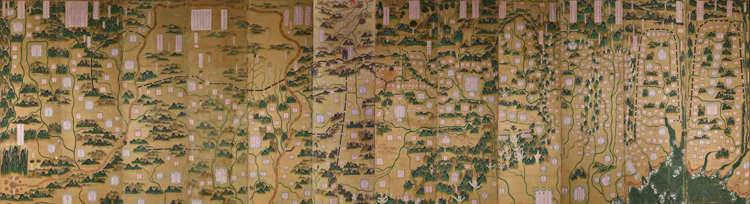
This is the Ming Dynasty "Nine Sides Map" screen in the precious collection of the National Museum
The map drawn extends from Shanhaiguan on the Liaodong Peninsula in the east to Jiayuguan in the west
The focus includes nine military towns in the Ming Dynasty, hence the name "Nine Sides Map"
Artifacts come alive
it
"Nine Sides" screen
(Technical support above: Shen Shen)
There are twelve paintings, each 183.8 in length and 55.4 cm in width.
Collection of the National Museum of China
The Ming Dynasty "Nine Sides" screen, a total of twelve paintings, each 183.8 in length and 55.4 cm in width. In 1959, it was allocated by the Cultural Relics Administration Committee of Hebei Province. The front of the screen is silk, pasted on twelve wooden boards, and the whole picture is drawn with a sketch map of realistic green and heavy color landscapes. From Shanhaiguan on the Liaodong Peninsula in the east to Jiayuguan in the west, there are nine border areas called "towns" in the middle, namely: Liaodong Town, Jizhou Town, Xuanfu Town, Datong Town, Yulin Town, Ningxia Town, Gansu Town, Taiyuan Town, And Guyuan Town, so it is named "Nine-Sided Map".
The map also details the geographical content of the towns within and outside the nine sides, such as Guanbao, Mongolian tents, mountains and rivers, etc., and the distance between the main towns is marked with miles. In the upper part of the eleventh painting, there is a preface to the ink book with the inscription "Jiajing Jia Wu April 6, the chief of the Qing Bureau, Lingbao Xu Zhizhi", which is originally copied and painted in the thirteenth year of Ming Jiajing (1534) and written by Xu Yan. On the back of the screen, the full text of the paper book "Hou Chibi Fu" is pasted, and the money is dropped: "Longqing Three Years of Spring and March, Zhi Wu Jinshi Dijing Camp Training Courageous Counselor General, Gu Yan Yang Jing Shan Ren Guo Quanren Shu", and two small square seals on the back.
Guo Quanren, the number of "YangJing Mountain People". Zheng Xiao, the governor of Caoyun, raised Guo Quanren around the thirty-third year of Jiajing, calling him "talented and determined", and in the "Book of Shangdong Xunyang" written by Yu Dayu to the official Shangshu Dongfen in the thirty-ninth year of Jiajing, guo Quanren, a protégé of Dong Fen, was mentioned under him, calling him "a man of letters and martial arts, who was out of the times". It is likely that this martial artist participated in the anti-Wu dynasty with Yu Dayu and made military merits, and after he received the "Nine-Sided Map" drawn by the military department, Yu Longqing wrote "Hou Chibi Fu" in three years to express his excitement. Although he is a military general, he does not lose his literary style at all, and his penmanship is vigorous and powerful, and he is completed in one go, giving people a sense of exhilaration.
In order to defend the Mongol southward movement, the Ming Dynasty began with the Ming Taizu Zhu Yuanzhang and gradually set up nine military towns on the northern frontier, which is the nine-sided defense system. Each town on the nine sides has a town guard general, a deputy general, a staff general, a guerrilla general, a garrison, a thousand generals, a general commander, and other officers, with no fixed rank and no fixed number. There were heavy troops stationed in the towns of the nine sides. The permanent garrison is called the main soldier, with a quota of about 600,000; in addition, there are temporarily mobilized troops, which are quite large. The nine-sided tunshu and the castles are everywhere, which is a barrier for the Ming Dynasty to resist the Mongol invasion, but in peacetime, it is also a zone for political and economic exchanges between the Ming and Mongolia.
Why is the Nine-Sided Diagram important?
Answer This map is used militarily to consolidate the border in the Ming Dynasty, comprehensively shows the overall situation and fortification of the Great Wall of the Ming Dynasty, and is the world's first map of the Great Wall that comprehensively reflects the defense system of the Great Wall, and the cultural relics are of extremely high value.
The Ming Dynasty "Nine Sides" screen in the National Museum is older in the surviving version of the same theme, the content is closer to the original work, the painter is the most exquisite, the most complete preservation.
Who is xu yan, the author of the Nine-Sided Diagram?
Answer Xu Yan was appointed by the imperial court in the twelfth year of Jiajing (1533) as the chief of the military department, and according to the various border defense atlases and archives submitted by successive border ministers, he compiled on April 6, 1307, the most important and well-known frontier history work of the Ming Dynasty, "Nine Border Maps", which described the situation of the northern border defense of the Ming Dynasty in the form of pictures and texts, so he became the right capital of the imperial history.
The Jiajing Emperor was very respectful of Xu Renqi and his Nine-Sided Diagram Theory.
Q Since it is a map, why not draw it using the "plan in the box" method (that is, a method of drawing a map at scale) to draw it?
Answer: Because the area depicted in the map is extremely vast, the terrain and landform are complex and changeable, and the realistic painting method is more intuitive, whether it is a civilian or military general, the content in the map can be seen at a glance. In addition, there is a reason that it is not a battle map, but a schematic diagram presented to the emperor.
Q Is there only one piece of the existing "Nine-Sided Diagram" of the National Bo?
A: No. The "Nine-Sided Map" in the collection of the Liaoning Provincial Museum is the most similar set to the collection of the Museum, but the preface is more wrong. In addition, there are some "Nine-Sided Diagram" series of illustrations (see table below).
<col>
serial number
name
era
Collection institutions
Basics
1
"Nine Sides"
bright
Sanmenxia Museum
Xu Wrote a copy of the Nine-Sided Diagram and left it in the ancestral hall of his hometown
2
National Museum of China
The green and green heavy color landscape painting method, twelve paintings, is basically complete, and the "Nine-Sided Diagram Theory" is relatively close to the age of the book
3
Liaoning Provincial Museum
Green landscape painting method, twelve paintings, the fourth "Xuanfu Town" is mostly missing, and the date of the imitation painting is thirty-seven years after Jiajing
4
Fragments of the Nine-Sided Diagram of the Painted Shen
Ming Wanli
The three towns of Liaodong, Jizhou, and Xuanfu are missing, and they were painted by Wanli Dynasty Shen With Shu, and the painting method is slightly rougher than that of Xu Yantu
5
National Palace Museum, Taipei
Woodcut ink prints, mutilated
6
The First Historical Archive of China
The woodcut ink seal is basically consistent with the collection of the National Palace Museum in Taipei and is complete
7
Late Ming Chongzhen period
Capital Library
Painted books, where there are ten axes, the second axis, and nine existing axes
8
"Northern Border Map"
The last years of the Ming Dynasty
Picture books, but many typos, variants, and white boxes that are not filled in
(Reference source for the above text: Wang Xiaowen)
Details are displayed
(Can you answer the little question at the end of the article?) )

Shanhaiguan in the first picture of the "Nine-Sided Map" screen
Jiayuguan in the twelfth picture of the "Nine-Sided Diagram" screen
The jizhen icon shows the number of miles from Yongping Province, Zunhua, and Miyun
The only inhabited island in the Yellow River, "Niangniangtan"
The inscription is the preface to the ink book "Jiajing Jia Wu April 6, the chief of the Qing Bureau, Lingbao Xu Zhi"
Bauhinia Pass and Futuyu in the picture. Most of the Great Wall in this area has not been built due to mountain dangers, and it is a hollow enemy building
Several lakes in the north of Daqingshan are depicted in the picture: Donghaizi, Xihaizi, Wild Horse River, Baihaizi, and Jininghai
Helan Mountain depicted in the picture. It can be seen that the figure on the right side is marked: there are zero thieves snooping at this time
The source of the Yellow River is depicted in the picture
The northwest pass of the imperial city shown in the picture. This ancient road is known as "Jundu Jing" or "Guangou" and connects the Central Plains with Saiwai
The imperial capital is shown in the picture
The figure shows the pastoral land of the liaodong chieftain xiao prince tribe
The Great Wall is shown lying across the rolling hills
Small question at the end of the article:
This arch bridge in the northeast of Liangxiang,
Which one?
Welcome to reply in the comments!
↓↓↓