It is Guangshan
Izu Oshima (hereinafter referred to as Oshima), located in the Pacific Ocean 60 kilometers south of Kanagawa Prefecture, is the largest island (91.06 square kilometers) of Tokyo's many outlying islands, and only 25 km from the Izu Peninsula nearest to Honshu, Japan, but is administratively under the jurisdiction of the Tokyo Metropolitan Government.
Depart from Takeshiba Port on Tokyo Bay at 10:00 p.m. on a large boat and arrive at Oshima early the next morning.
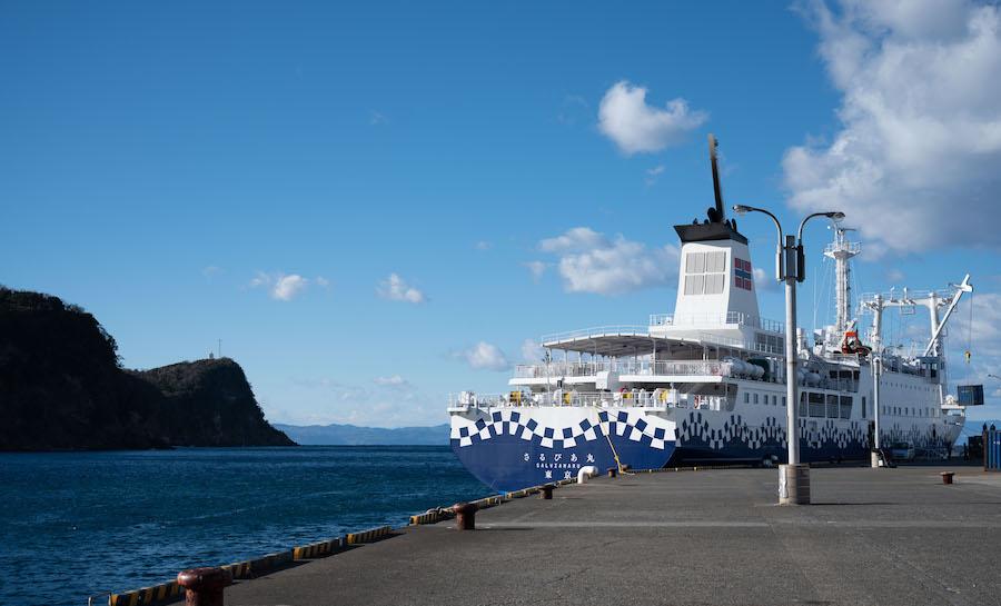
Cruise ships became the main mode of transportation for the Big Island and the outside world. The pictures in this article are all pictures of the author's Guangshan
The history of human habitation on Oshima dates back to the Jomon period, and there are the oldest remains of Takahashi Cave, dating back more than 8,000 years. Due to its remote location, Big Island used to be a penal colony for degraded people.
According to available records, about 150 people were exiled here, including many well-known figures in Japanese history, such as Emperor Tenmu's son, the founder of Shukudo, Yu Kokaku, genze Dynasty, who was defeated in the Hokumoto Rebellion, and Ako Yoshishi, one of the forty-seven soldiers.

View of the port
In 1946, the GHQ ordered the administrative separation of the Izu Islands, and Oshima was briefly separated from Japan (after the end of World War II, MacArthur established the Allied Supreme Commander-in-Chief General's Headquarters in Tokyo in order to implement the U.S. government's policy of "occupying Japan alone". General Headquarters in English and "GHQ" in Japanese). After 53 days, through the efforts of the Japanese government, Oshima returned to Japan's embrace. In 1955, after the merger of the municipalities of Oshima, the current town of Oshima was formed.
"Restless" volcanic craters and black deserts
As a volcanic island, the experience of volcanic landforms is definitely not to be missed.
Mt. Mihara on the island is 758 meters above sea level and is a central crater hillock formed by the collapse of the volcano at the top of the mountain. In 1777, the EY volcano erupted, causing the crater at the top of Oshima to crack open 300 meters in diameter and 200 meters deep, and every 35 years or so, the volcano erupted continuously, gradually forming the current appearance of Mt. Mihara.
Mihara Mountain in the early morning
There are a number of sightseeing trails built around the summit of Mihara Mountain, and visitors can take a few steps from the summit of Mihara Mountain to see the Outer Wheel Mountain Observation Deck, standing on the observation deck, the entire Mihara Mountain can be seen, and at the same time, you can see the various black lava flows formed by the volcanic magma flowing below.
However, due to the volcanic eruption in 1986, part of the trail was destroyed by magma, and visitors can only step on the uneven lava flow, imagining the spectacular scene of the volcanic eruption in that year, on the way to the crater, you can also see large pieces of igneous clastic rock, which is the accumulation of a large number of lava droplets produced during the volcanic eruption.
The road at the top of Mt. Mihara
The road along Mt. Mihara is filled with accumulation formed after a volcanic lava flow
There is a Mihara Shrine near the crater, and it is said that during the 1986 volcanic eruption, the shrine miraculously survived the lava, so it is considered by the locals to be the providence of the "fire god", and many pilgrims come to worship every year to pray for peace. Starting from the shrine, walking along the sightseeing trail by the crater is another very special experience: from time to time, you can see steam gushing out from the crevices of the rocks, touch the soil with your hands, and you can feel the warmth from the bottom; the sound of the fierce wind at the top of the mountain and the creaking sound of your feet on the lava; looking down to the crater, it is a bottomless darkness; looking up, you can see the not far away Rishima, Nisejima, Shigenoshima, and Kanzu Island, and even Mt. Fuji across the sea is extremely clear.
The roads around the crater are lava all the way
Geothermal fumes still erupt near the crater
Huge crater at the top of the mountain
It takes about an hour to walk around the crater, as it is sparsely populated and hardly anyone is encountered along the way.
At the top of the mountain, you can look out over several nearby Tokyo outlying islands
The ctenophoric mountain area in the east of Mihara Mountain, known as the "Ri Desert", is another major attraction in addition to the crater. This is the only place on the map issued by the Japan Academy of Land Geography that has been marked as a desert, and all you can see is the black earth made of black sand grains, which makes people feel like landing on Mars at the moment of arrival, which is very wonderful. These black sand grains are not ordinary sand grains, but volcanic slag discharged from each eruption of the crater. The strong winds on the mountain all year round make it difficult for ordinary plants to take root and survive, which gradually forms this desolate black desert.
A large desert, empty
Standing at the top of Mount Ctenos, the 2nd Observation Deck of the Riku Desert can 360 degrees around the entire black desert like the lunar surface craters, and as a very rare desolate scenery in Japan, the Rikyu Desert has also become a filming location for many advertisements and singers' MVs, and Japanese artists such as Ryo Nishikido, Oguri Shun, GLAY, Nogisaka 46, GReeeeN and other Japanese artists have filmed here, showing the unique charm of this black desert.
The first observatory in the Desert
Izu Dancer's Bofu Port
Frequent volcanic activity has not only created the magnificent Mihara Mountain crater and desert, but also created the wave floating port of Oshima.
The Bofu Port area was once a crater lake, which was connected to the sea by a tsunami caused by the Motoroku Kanto earthquake in 1703. In 1800, a merchant named Qiu Guangping Liu took the lead in building a port here by cutting cliffs, and gradually formed the appearance of the current port. Later, as a safe haven for ships and a relay station for distant-water fishing, the port of Bofu flourished for a while.
In 1889, the Tokyo Bay Steamboat Company was established (the predecessor of the current Tokai Steamboat Co., Ltd.), and in 1891 a regular route was opened connecting Oshima with other outlying islands. From the end of the Meiji era to the Taisho era, many literati and inkers visited Oshima through this route, and left many works with the theme of Bofu Port, such as yasunari Kawabata's short story "Izu Dancer" the protagonist and the hometown of the prototype from Bofu Port; in 1928, "Port of Bofu" composed by Yuharu Noguchi and composed by Shinpei Nakayama came out, becoming a well-known song at that time, and also made Bofu Port famous. Today, many of the historic buildings that still remain near the port are reminiscent of the lively port scene of the time.
Bofu Port Observatory
If you want to get a panoramic view of Bofu Port, then Bofu Port to see Qingtai is the best choice. Located on the highlands near the port of Bov, the observatory offers a purse-shaped silhouette of the entire port, as well as the quaint old-fashioned houses nearby. In 1960, the Emperor of Japan visited Oshima and made a special trip to overlook the port of Bofu, which shows the status of The port of Bofu on the big island.
The Port of Bofu Observatory overlooks the Port of Bofu in the distance
From the port of Bofu along the northern coastal road, you will also see a reef rock about 30 meters high standing on the sea, because of its shape similar to the tip of the pen, known as "Pen Island", which is a landscape of lava channels left by volcanic activity after a long period of erosion. After looking at Pen Island, you can walk along the seaside trail to Bofu Harbor, which is lined with 33 stone tablets with poems made by literati and inkers, so it is also called "the way of literary walking". While admiring the vast Pacific Ocean view, while reading the poems describing the bofu port with Xie Ye Jingzi and Yan Gu Xiaobo, not only let people have a new understanding of this ancient port.
Standing on pen island by the sea
Literary promenade by the sea
A huge cross next to the literary promenade
If you have enough time, you can also visit the magical Stratigraphic Cutter by the Southern Coastal Highway. The 24-meter-high, 630-meter-long, 2-meter-long, annual-ring cake-like stratum is said to have formed after numerous volcanic eruptions 15,000 years ago, and is now a popular "punch card resort" for young people. Alternatively, you can visit Metropolitan Oshima Park in the east, the largest camellia park in Japan with 5,000 camellia trees, and learn about Oshima's long history as a camellia oil producer at the Camellia Museum in the park.
The formation is cut off by a large section of the southern coastal road
The boom in "outlying island tours" in the last century brought a large number of tourists to the big islands, but the number of tourists has fallen sharply compared with its heyday. But once you've been to Oshima, you'll be sure to make unforgettable memories of its unique natural features and customs.
Editor-in-Charge: Wang Yu
Proofreader: Luan Meng