According to the China Weather Network, since May 10, South China and other places have suffered the strongest rainfall process since the flood this year, involving a wide range, a long duration, a large cumulative rainfall, and a high risk of disasters, and the local daily rainfall has exceeded the historical extreme. The Central Meteorological Observatory issued the earliest orange warning of heavy rain in the past decade on the 11th. Affected by the torrential rain, guangzhou, Zhuhai, Zhongshan and other places have suspended classes in the city, and some trains in Shenzhen have been suspended and adjusted. So, how big is the heavy rainfall in South China? How long will it take?
First, how much heavy rainfall will fall in South China?
In the past three days (10 to 12 days), south China and other places have experienced the strongest rainfall process since the flood this year, with heavy rains in parts of central and eastern Guangdong, southeastern Guangxi, southeastern Fujian and other places, and heavy rainstorms in Zhuhai, Jiangmen, Shenzhen, Shanwei, Heyuan and Zhangzhou, Fujian, guangdong, and locally.
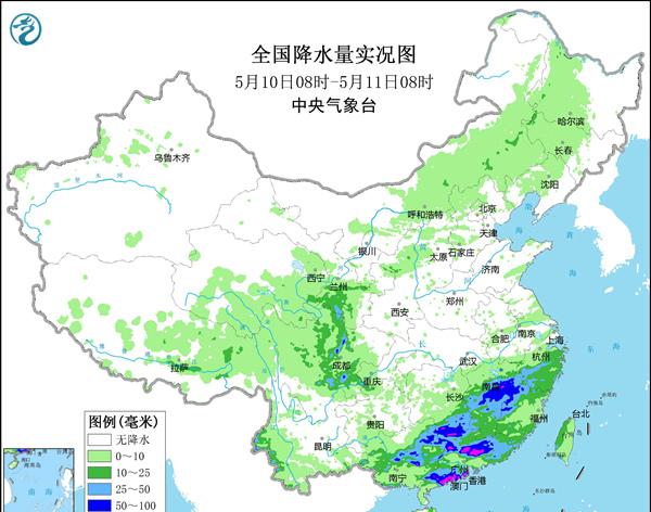

According to statistics from 08:00 on the 10th to 08:00 on the 13th, a total of 99 stations in Guangdong, Guangxi and Fujian have experienced heavy rain at 99 stations. Among them, the single-day rainfall in Xinxing, Guangdong, Lufeng Caoyu Island and other places broke the extreme value of mid-May. The cumulative rainfall in Zhuhai, Fogang, Doumen and other places is more than 300 mm, more than three times the average precipitation in mid-May.
2. Where is the rainstorm center?
Since May 10, the area of heavy rainfall has been mainly concentrated in south China, and the central and southern coastal areas of Guangdong are the center of heavy rainfall. From the 10th to the 12th, 6 to 8 national stations in Guangdong had heavy rainstorms of more than 100 mm every day, and Doumen and Zhuhai reached the magnitude of heavy rainstorms for three consecutive days.
Among them, the cumulative rainfall in Zhuhai from 08:00 on the 10th to 08:00 on the 13th reached 505.4 mm, more than 6 times the average precipitation of the local area in mid-May, and close to the annual precipitation in Beijing. In addition, the rainfall of Doumen and Fogang is more than 3 times that of the average precipitation in the same period of the year.
3. How long has the heavy rainfall fallen in South China?
The precipitation process in South China began to develop from west to east and from north to south from the day of May 10, taking the lead in northern Guangxi, and then developing to Guangdong, Fujian and other places, and is still continuing. As of today, the rain has been continuous for 4 days, and the strongest period is from the night of the 10th to the 13th.
How long will it rain?
In the next three days, the scope of heavy rainfall in south China will gradually shrink, but there will still be significant precipitation in southern Guangdong, fujian coast, southeast Guangxi, eastern Hainan Island, Taiwan and other places. It should be noted that on the 13th, there were still heavy to heavy rains in parts of the southern coast of South China and most of Taiwan Island, among which there were heavy rainstorms (100 to 150 mm) in parts of the southeast coast of Guangdong and the north-central part of Taiwan Island, and some areas were accompanied by short-term heavy precipitation, and there were strong convective weather such as thunderstorms and strong winds. By the night of the 15th, the heavy rainfall process in South China will end.
In addition, the soil moisture in central and northern Guangxi, Guangdong, southern Fujian and other places that encountered heavy rainfall in the early stage is relatively high, and geological disasters have a certain lag, and it is still necessary to prevent the occurrence of local waterlogging, flash floods and geological disasters.
Fifth, why is the process of heavy rainfall so fierce?
Wang Weiyue, a meteorological analyst at China Weather Network, explained that due to the continuous arrival of warm and humid air currents from the Bay of Bengal and the South China Sea, while the low vortex and the eastward movement of high-altitude troughs provide precipitation power conditions, and finally coupled with the rare strong cold air relay in the same period, a variety of factors have collectively caused heavy rainfall to occupy the south of China.
Does this rain mean that South China has entered a period of concentrated rainstorms?
The heavy rainfall weather process in the south can be said to be a signal of the summer wind outbreak in the South China Sea. According to the National Climate Center's forecast of the East Asian summer wind circulation, the South China Sea summer wind will erupt in the third season of May (May 11-15), slightly earlier than the usual year (may 4th weather), and the intensity is close to or weaker than usual. After the outbreak of summer winds in the South China Sea, the mainland will fully enter the main flood season.
For the mainland, usually within two weeks after the outbreak of the summer wind in the South China Sea, the monsoon air current will carry more abundant southwest warm and humid water vapor from the tropical Indian Ocean and the South China Sea into the East Asian continent, and the convective heavy precipitation in the southern part of the continent will increase significantly, and the southwest rainy season and plum rain will begin one after another, and the mainland will fully enter the main flood period.
However, according to this year's climate forecast, it is expected that from mid-May to early June, with the adjustment of the circulation situation, the precipitation intensity of most of South China will be significantly weak, but it is still necessary to guard against the staged heavy precipitation process and strong convective weather such as thunderstorms and strong winds.
Edited by Linzhi Sun