The ancient city of Guizi, also known as "Mazabutan Ancient City" and "Pilang Ancient City", is located in Kuqa Town, Kuqa County. The city is mainly farmland and residential areas, and Tianshan Road (formerly National Highway 314) passes through the city. In 1961, it was announced as an autonomous region-level cultural relics protection unit, and in 2013, it was approved and announced by the State Council as a national key cultural relics protection unit.
According to Huang Wenbi's 1958 survey, the city site was large in scale, with an irregular square plan and a circumference of about 7 kilometers. The city wall can be seen on the north, east and south sides, and the west side is not seen. The walls are winding and rather untidy. The walls are earthen and the rammed layer varies from 6 to 30 cm thick. The north wall is 2075 meters long, the soil is yellow-red, the soil is fine, the wall is 3.8 meters high, 8 to 16 meters wide, and there are several sections of the city wall that are rammed under the wall, and the upper part is built by adobe and sand, which may be a secondary construction. The east wall is 1608 meters long, the wall is well preserved, the residual height is 7.6, and the width is 15 meters. The wall has a battlement every 40 meters, commonly known as horse face, 4.8 meters long and 4.8 meters wide, the wall is yellow-brown, rammed earth, rough soil, containing stones or pottery pieces, etc., and may also be rebuilt. The total length of the southern wall is 1809 meters, only two sections remain today, one section is in the southeast of Pirantula, the rammed city wall, the east-west remnants are 20 long, 2.8 wide, 3.5 meters high, the soil is fine and clean, yellow-red, and the other section is southwest of Pirantula, with a residual length of 10 and a height of 2 meters. The Western Wall is gone. There are 6 large mounds in the city, known locally as "Tula", namely Saksak Tula, Nanhai Dun, Ukutula, Baijian Tula, Hala Dun and Pilang Tula. There are 5 ruins outside the city, namely the ruins of Querupak Tula (A), QueruBak Tula (B), Choruhara, Shayabak Tula and Mazafutang. Excavations at Karadun have unearthed relics such as early Iron Age faience pottery pieces and large tang dynasty pottery jars.
Due to the serious damage caused by urban construction and agricultural production, the ancient city of Guizi has been seriously damaged, and both inside and outside the city are occupied by villages, towns and farmland. From 1989 to 1990, when the second national cultural relics census was conducted, there were very few remnants of the ancient city of Guizi. The north wall is about 1100 meters long and consists of two sections. The western section is located on both sides of the Uka Highway, about 400 meters long, the base of the wall is 2 to 9 meters wide, and the height varies from 0.2 to 7.4 meters, with two gaps in the middle. The eastern section is about 700 meters in its east, the length of the remnant is about 10 meters, the base width is about 5.3 meters, the height is about 5.6 meters, and the rammed layer is 6 to 30 centimeters thick. Parts of the city walls were repaired with green bricks and adobe. The remnants of the eastern wall are 136 meters long. The remnants of the southern wall are about 11.4 meters long and are located in the southern residential area of the county. In 2009, during the third national census of cultural relics, the only remaining section of the east wall, which is about 136 meters long, also disappeared. Within the scope of the ancient city, there are still remnants of piers such as Piran Dun, Hala Dun, Saxonk Mound, Lokkai Mound, etc., and the nature of these mounds is unknown. Outside the scope of the ancient city, there are Shaka Utur Beacon Towers in the east; in the northwest there are Isiharatur and Kuokong Baizi Tur Beacon Piers; and in the west there are Koxitur and other beacon tower architectural sites that have been excavated in the Old City over the years. There are mainly coins and architectural decoration materials of the Han and Tang Dynasties, such as carved lotus patterned stone pillar foundations, lotus pattern square bricks paved on the floor, molded pattern tiles and lotus pattern tiles, barrel tiles, plate tiles, etc. Most of the pottery is red pottery with sand, and there are fewer sand and gray pottery. Wheeled, yellow-red or yellow-brown pottery coat, mostly plain surface, vessel shapes include pots, urns, pots, cups, jars and pygmites.
In 2016, with the approval of the State Administration of Cultural Heritage, the Xinjiang Institute of Cultural Relics and Archaeology conducted exploration of the ancient city wall, excavated the eastern end of the south wall, and in September rescued and cleaned up some of the remains exposed in a construction site in the west of the city, covering an area of about 700 square meters. Clear 1 brick road (Figure 1). The brick path is tiled with green bricks and paved with a straight, one-by-one or herringbone. Locally damaged, the mutilated parts are filled with yellow-brown road soil. At the junction, each is paved with round clusters of flowers (Fig. 2). A row of bricks is placed horizontally on each side of the brick road as a curb, and the outside of the joint is reinforced by triangular bricks. Bricks are divided into two types: long strips and squares. The back of the long bricks is molded with palm prints, the square bricks are back with cloth patterns, and in November and December, anatomical excavations of the eastern part of the south wall in an orchard and nursery field in the Pilang community were carried out, covering an area of 300 square meters. Clear out the remains of the city wall, moat and other relics (Figures 3 and 4). The total area of the two excavations is 1,000 square meters. The city wall consists of the main wall and the north and south sides of the parapet, which is attached to the outside and extends longer at the bottom. Rammed, the main wall rammed tightly, the rammed layer is clear, 7 to 25 cm thick. Contains a small amount of pottery flakes and animal bones. The rammed wall is loose and the rammed layer is not obvious, containing pottery pieces, palm-patterned brick pieces and animal bones. The width of the base of the wall is 22 meters, the width of the top residue is 13.3 meters, and the height of the remnant is 3.3 meters. The moat is located on the outer side of the city wall, and the north embankment breaks the foundation of the south parapet of the city wall. Profile U-shape. The mouth is 7.5 meters wide and the residual depth is 3.1 meters. The fill contains collapsed soil, flood silt and sedimentary clear sand. 80 relics were unearthed. There are mainly pottery, stone tools, as well as building materials and coins.
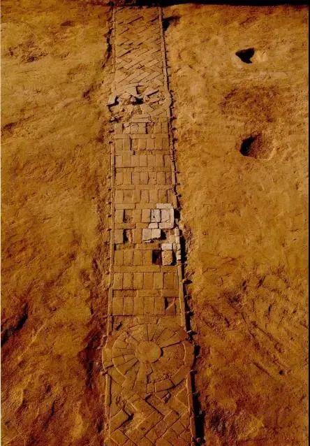
Figure 1 Brick road

Fig. 2 Clusters of flowers on the brick road
Figure 3 Floor plan of the trench exploration of the southern wall of Guizi City
Fig. 4 Panoramic view of the city wall and moat in the eastern section of the southern wall
Figure 5 Excavation area of The ancient city of Guizi in 2017
In 2017, archaeological excavations continued at the site of the City's Qanteyindun (Figure 5), with an excavation area of 500 square meters. The ruins include 6 housing sites, 1 courtyard, 13 ash pits, 5 stove pits, 5 pillar holes and 1 high platform building, while 10 late tombs were cleaned up, and some houses were broken by tombs. The house and the courtyard plan are rectangular, and the walls are made of adobe and padded with mud between the adobe. There are symmetrical semicircular column holes in the walls of the house. Clay pieces, copper, iron, coins and animal bones are filled. Ash pits are round, semicircular, horseshoe-shaped and irregular, and contain pottery pieces and animal bones. The plane of the stove pit is irregular, the four walls have obvious traces of fire, and the pit has ashes and residual iron utensils. High-rise buildings are also built with adobe barriers. Excavated relics include pottery, copper, iron, stone, coins, etc., mostly pottery, pottery is a remnant, some can be restored, the production method is wheeled, mainly clay red pottery, most of them are yellow skin red tires. Utensils include bowls, bowls, pots, pots, lamps, koshiki, etc., and the ornamentation includes cirrus patterns, grass leaf patterns, lotus petal patterns and draped tent patterns, etc., and individually pastes the figures and animal figures on the surface of the utensils. Copper, iron, stone tools are all daily necessities, including copper ornaments, iron knives, stone grinding discs, etc., coins have scissor wheel five baht, turtle money, etc., mostly turtle money. According to the cleaned ruins and excavated relics, it is preliminarily judged that the main age of the site is the Tang Dynasty.
Xinjiang Kuqa region (i.e. Guguizi), located at the crossroads of east-west traffic, is a famous oasis on the ancient Silk Road, a necessary place for the north of the Silk Road in history, and one of the important political, economic, cultural and trade centers in the Han and Tang dynasties in the western region. The "Book of Han and the Biography of the Western Regions" says: "Guizi Kingdom, Wang ZhiYancheng, went to Chang'an for 7,480 miles." There were 6,970 households, 81,317 mouths, and 21,76 victorious soldiers. Dadu Wei Cheng, Fu Guo Hou, An Guo Hou, Hu Hou, Hu Du Wei, Shu Du Wei, Left and Right General, Left and Right Du Wei, Left and Right Rider Jun, Left and Right Auxiliary Jun, two each of the East, West, South, and North Qianchang, three Hu Jun, and four translators. It is bordered by Jingjie to the south, Zhimu to the southeast, Yumi to the southwest, Wusun to the north, and Gumo to the west. Can be cast, there is lead. To the east, it is three hundred and fifty miles from the capital protector Wulei City. "In 60 BC, the Western Regions Capital Protectorate was established in Wulei (present-day Luntai County), and Xinjiang was incorporated into the Chinese territory and became an inseparable part of China. At the end of the Eastern Han Dynasty, the Western Regions Capital Protectorate was once moved to Yancheng; the Tang Dynasty established the Anxi Metropolitan Protectorate in Guizi Irolu City, which led the 22 capital protectorates in the Western Regions and the garrisons of the four towns of Guixuan, Yanqi, Khotan, and Shule. From the Five Dynasties to the Song Dynasty, it was called Guizi Uighur, and during the Yuan and Ming Dynasties, it was renamed Yili Baali. In the twenty-third year of the Qianlong Dynasty (1758), it was named Kuche and set up a minister of Kuche Affairs. In 1884, Kucha was directly subordinate to the Fumin Department, which had jurisdiction over the current Shaya and Xinhe counties. In 1902, Kucha Prefecture was reorganized into Kucha Prefecture, which belonged to Aksu Province and had jurisdiction over Shaya County. In 1913, Kuqa County was reorganized, and in 1922 it was subordinated to the Office of the Administrative Inspector of the Fourth District of Xinjiang Province. In 1950, it belonged to Aksu Prefecture and set up Kuqa Town. In 1971 it was subordinate to the Aksu region. According to research, the ancient city of Guizi is the "Yancheng" of Guizi in the Han Dynasty and the former site of the "Irolu City" in the Tang Dynasty.
Guizi guarded the middle section of the northern route of the ancient Silk Road, connecting trade and civilization between the East and the West, and was extremely developed in economy, culture and art, and also occupied an important position in the world economy and cultural history. The political, economic and cultural exchanges between China and the West on the Silk Road greatly promoted the social and economic prosperity of Guizi, and on this basis, the brilliant Guizi culture was produced and enjoyed a high reputation. In terms of music and dance, he is an outstanding representative of Western music and dance. As early as the Han and Tang Dynasties, Guizi was known as the "Western Music Capital" by the West, known as the "Hometown of Song and Dance", and the famous Guizi Music and Dance was born here. In terms of Buddhist art, it has a more ancient history of grotto art than the Mogao Grottoes, and the Buddhist murals and statues in the grottoes and Buddhist temple sites, as well as the Guizi and Chinese inscriptions are more eye-catching. Today, the Guizi region also preserves a large number of cultural remains containing ancient Indian Gandhara, Guizi and Central Plains Han civilizations, including ancient cities, cave temples and Buddhist temple sites, as well as various other types of sites and a large number of tomb groups. As representatives of the ancient Guizi culture and as an important part of Chinese culture, they still play a role in educating people with history.
As the seat of the Western Regions Protectorate of the Han Dynasty and the Anxi Metropolitan Protectorate of the Tang Dynasty, the Ancient City of Guizi was the political, economic, cultural and transportation center of the central government in the Western Regions during the Han and Tang Dynasties, and has an important historical position and academic significance in the process of Xinjiang's historical evolution and the great process of the great unification of the Chinese nation, and is of decisive importance to the study of the historical changes in Guizi, the evolution of the Central Plains Dynasty's governance of the frontier areas, and the economic and cultural exchanges between China and the West.
(The picture and text are transferred from: "Cultural Relics Heaven and Earth Monthly" public number)