Since the 1990s, volcanic eruptions and seismic events have occurred frequently around the world, and Japan has occupied the two major scourges of volcanoes and earthquakes, and the potential threat cannot be underestimated. According to the law of activity, the tectonic movement of volcanoes and earthquakes in Japan has entered an active period, and Mt. Fuji is therefore in a state of high attention.
According to the characteristics of volcanic eruptions, people divide volcanoes into three types: extinct volcanoes, dormant volcanoes and active volcanoes, and Mt. Fuji in Japan is a typical representative of dormant volcanoes. Japanese geologists have pointed out that Mt. Fuji is in the fault zone of plate tectonics, and when the internal energy accumulates to a certain extent, it is possible to form a volcanic eruption, and the consequences are unimaginable.
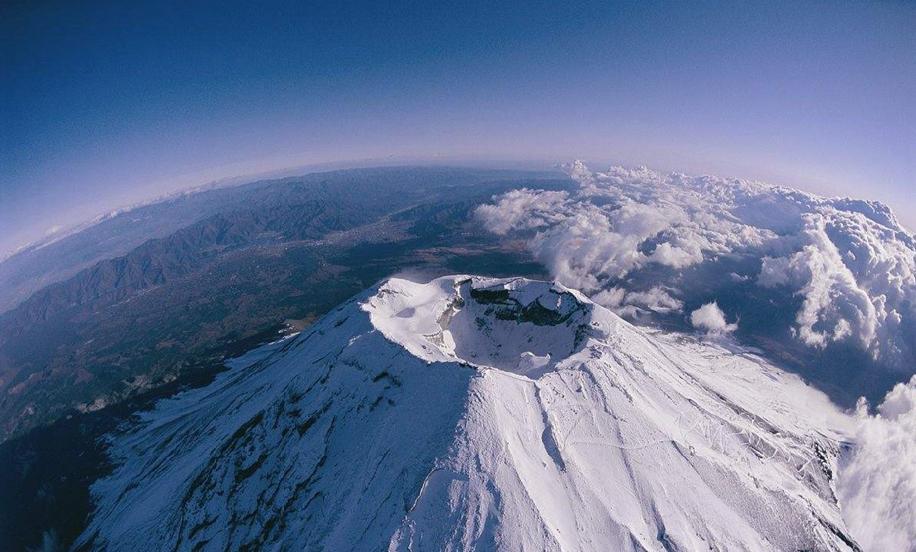
Mt. Fuji is the highest peak in Japan, with a maximum altitude of 3775.63 meters, and the mountain is located 85 km southwest of Tokyo, spanning Yamaryo Prefecture and Jinggang Prefecture. Mt. Fuji is the largest volcano in the Fuji volcanic belt, with a conical shape, a bottom circumference of about 125 km and a diameter of 40 to 50 km, and a narrowing of the top crater, with a diameter of about 500 m and a depth of only 250 m.

According to historical records, since 781 AD, Mt. Fuji has erupted 18 times, and the last eruption was in 1707, 314 years ago. According to the investigation, the volcanic eruption in 1707 produced a large amount of volcanic ash, spreading a distance of hundreds of kilometers, accumulating 4 centimeters of volcanic ash in the urban area of Tokyo. To this day, sulfur gas still escapes near Mt. Fuji, and the surrounding plains are often accompanied by seismic activity, which locals have become accustomed to.
Recently, the earthquake in Japan seems to be on the rise again. On the evening of October 7, local time, a 6.1-magnitude earthquake occurred in Chiba Prefecture near Tokyo, Japan, with a depth of 80 kilometers, and local residents were caught off guard. The maximum magnitude measured in Tokyo's 23 wards and southern Saitama Prefecture exceeded magnitude 5, causing many traffic accidents and temporarily closing shinkansen railways, airports, and highways.
According to the Japan Meteorological Agency, the earthquake has not yet triggered secondary disasters such as tsunamis, but according to forecasts, it is likely that there will be another earthquake of magnitude 6.0 or higher in the coming week.
From 2011 to 2020, there were more than 100 earthquakes of magnitude 7 or above in Japan, with an average of about 10 per year. Among them, the most frequent earthquakes occurred in 2011, with 34 major earthquakes and 19 in 2016. Some people have done rough calculations, and the energy released by a magnitude 7 earthquake is equivalent to 477,000 tons of explosives, which is more than 30 times that of a magnitude 6 earthquake. As for the magnitude 8 earthquake, the consequences will be even more unimaginable!
Let's first understand the causes of the volcanic eruption.
Interaction of continental plates
The subduction zones or collision zones of major plates rub against each other to form local high temperatures, especially at the edges of the plates, where the geological structure is relatively fragile and the geological structure is prone to fracture. At this point, the relative movement of the plates may form magma sacs, which is a direct trigger for volcanic activity.
As we all know, the Japanese archipelago is located in the Pacific Ring of Volcanic Belt (the junction of the Pacific Plate and the Eurasian Plate), which is home to more than 370 active volcanoes, accounting for more than 75% of the global total. It is worth mentioning that the Pacific Ring of Volcanic Belt and seismic belts are highly overlapping and are a direct product of plate movement.
The squeeze of pressure inside the Earth
The Earth, from the inside out, is the core, the mantle, and the crust. In the Earth's interior, rock minerals are molten due to high temperatures and high pressures. The temperature and density of the magma are unevenly distributed, and convection occurs at the mantle or forms mantle columns. When the high-temperature rock mass rises to the surface of the mantle, it melts due to reduced pressure and eventually accumulates to form a magma sac.
When the pressure inside the magma sac is greater than the surface pressure, the magma inside will gush out along the fault layer or pore, eventually leading to volcanic eruptions. If the magma overflows the surface along the crack, it is called a fissure eruption, there is no strong explosion phenomenon, and the lava terrace is formed after cooling; if the underground magma gushes out through the crater channel, it is called a central eruption, which is the most common form of eruption in the Fuji volcanic belt.
Center-type eruption
From the perspective of the cause of formation, the earthquake may indeed become the "black hand behind the scenes" of volcanic eruptions, especially large earthquakes of magnitude 8 or above, which have a considerable probability of becoming the fuse for the eruption of Mt. Fuji. Practical cases also show that the places of occurrence between volcanoes and earthquakes are generally very close, and large earthquakes are often precursors and signals for volcanic eruptions. For example, the eruption of Mount Fuji in 1707 actually began to erupt 46 days after the 8.6 magnitude earthquake of that year.
On October 9, 2021, HKT published an article pointing out that this year, the geological activity around Mt. Fuji has suddenly increased. As early as March 26, Japan's Mt. Fuji Volcano Disaster Prevention And Countermeasures Committee released the latest "Mt. Fuji Eruption Risk Area Map", which is also a new round of revision after a gap of 17 years.
As can be seen from the newly revised risk map, the potential volcanic magma and volcanic ash around Mt. Fuji are a full circle. According to the forecast, the area around Mt. Fuji will be the most severely affected, and the thickness of volcanic lava and volcanic ash coverage will reach 50 cm, and the thickness of volcanic ash coverage will reach 2 to 10 cm in downtown Tokyo, 100 km from Mt. Fuji.
If Mt. Fuji were to erupt again, the potential disaster would cover 27 municipal districts in Japan, including densely populated areas such as Tokyo, Chiba, and Kanagawa.
In fact, "evidence" that Mt. Fuji is at a tipping point in the eruption has long been known. In 2014, a scientific team composed of France and Japan conducted a special survey of Mt. Fuji and found that the lava under Mt. Fuji was under "extreme pressure" and had reached a critical state. The results were eventually published in the internationally renowned journal Science.
Another "proof" is the disappearance of snow. In 2020, the snow on the summit of Mt. Fuji has disappeared abnormally, and the time is still in the cold winter. You know, the local winter temperature is below minus 16 degrees Celsius, and under normal circumstances, the snow cannot melt at all. As for the reason for the disappearance of snow, the mainstream view is related to the heat released by underground lava activity. In view of the ominous signs, the Mt. Fuji Disaster Prevention Committee also formulated a new evacuation plan on September 2 this year.
Experts from the Disaster Prevention Committee pointed out that Mt. Fuji has been dormant for more than 300 years, and the lava accumulation is very large, and it is likely that it will erupt on a large scale again. At that time, there will be more than 250 craters in the Fuji Volcanic Belt, a four-fold increase in number compared with the original 44 craters. According to the model, the amount of volcanic ash spewed out will reach a horror magnitude of 10 million m³, which is 4 times higher than the value predicted 17 years ago.
In the past two years, Japan has formulated an emergency plan for earthquakes of magnitude 8 to 9 in the next 10 years, and after the earthquake, the long-dormant Volcano Offilm may usher in a new round of eruptions.