@Hokkien people, pay attention!
Cold wave + typhoon hit,
Affected by strong cold air,
Since today, the temperature in all parts of the province has dropped significantly,
Please pay attention to the temperature change,
Add clothes in time oh~
Cold wave blue warning
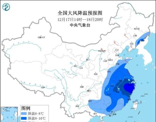
The Central Meteorological Observatory continued to issue a cold tide blue warning at 10 o'clock on December 17:
Affected by cold air, it is expected that from 14:00 on December 17 to 20:00 on December 18, Huanghuai, Jianghuai, Jianghan, Jiangnan, South China, as well as eastern Jilin and eastern Liaoning will cool down by 6 to 8 °C, of which parts of eastern Jiangnan will cool down by more than 10 °C. On the morning of December 18, the minimum temperature line of 0 °C is located in the southern part of Zhejiang to the northern part of the Sichuan Basin. Inner Mongolia, the southern part of the northeast region, north China, Shandong Peninsula and other places have 4 to 6 northerly winds and 7 to 9 gusts; in the eastern and southern waters of China, there will be strong winds of 7 to 9 and gusts of 10 or more.
Defensive guidance:
1. Personnel should pay attention to adding clothes to keep warm; in production, be prepared for the defense of windy cooling weather;
2. Doors and windows, enclosures, scaffolding, temporary structures and other structures that are easily blown by high winds are tightened, and outdoor items that are susceptible to high winds are properly placed;
3. You should go to a sheltered place to avoid the wind and notify outdoor operators to pay attention to safety;
4. Keep an eye out for the latest information on wind cooling reported by media so that further measures can be taken;
5. Transportation, public security and other departments should make preparations for road icing in accordance with their duties.
Typhoon blue warning
The Central Meteorological Observatory issued a typhoon blue warning at 10 o'clock on December 17:
The center of this year's No. 22 typhoon "Rey" (strong typhoon level) is located at 8 o'clock in the morning today (17th) in the Sulu Sea in the Philippines, about 890 kilometers east of Nansha Fiery Cross Reef in Hainan Province, China, that is, 10.2 degrees north latitude and 121.1 degrees east longitude, the maximum wind near the center is 14 (45 m / s), the minimum pressure of the center is 950 hPa, the radius of the seventh wind circle is 350-380 kilometers, the radius of the tenth wind circle is 160 kilometers, and the radius of the twelfth wind circle is 70 kilometers.

It is expected that "Rey" will move in a westerly direction at a speed of 25-30 kilometers per hour, and will move into the southeastern sea surface of the South China Sea this evening, gradually increasing in intensity; around the 19th, it will gradually turn to the northerly direction and move closer to the eastern sea surface of China's Hainan Island, and the intensity will gradually weaken.
High wind forecast
From 14:00 on the 17th to 14:00 on the 18th, most of the South China Sea, the Zhongsha Islands and the Xisha Islands will have 8-9 gales, the southern part of the South China Sea and the Nansha Qundao will have 10-12 gales, and the winds on the nearby seas and islands through the center of "Rey" will have 13-16 winds, and gusts of 17 and above.
The Fujian Meteorological Observatory issued a cold wave warning
The Fujian Meteorological Observatory issued a cold wave warning at 12:00 on December 17, 2021: Due to the strong cold air, the temperature in various parts of the province has dropped significantly since today. The process of the minimum temperature can be reduced by up to 10 to 12 °C in the western and northern regions (some counties and cities will have a cold wave), and the rest of the areas will be 6 to 10 °C. The lowest temperature appeared on the 19th, and the minimum temperature in most of Nanping, western Sanming, northern Longyan and northern ningde could reach 0~4 °C (high-altitude mountainous areas were below -1 °C), the urban areas of central and southern coastal counties and cities were 8 to 10 °C, and the urban areas of the rest of the areas were 4 to 8 °C. Some counties and cities in the western and northern regions have frost or frost, and there is localized ice.
The Fujian Meteorological Observatory issued a warning of high winds at sea
The Fujian Meteorological Observatory issued a maritime gale warning at 12:00 on December 17, 2021: Today, during the day to night, the northern coast: northeast wind 6-7 gusts 8-9 to 7-8 gusts 9; the central coast: 7-8 gusts 9-10 to 8-9 gusts 10 short-term gusts 11; the southern coast: northeast wind 7-8 gusts 9 to 7-8 gusts 9-10; Taiwan Strait: northeast wind 8-9 gusts 10-11.
At 0:00 a.m. today,
There are 48 counties and cities in the province where the temperature is above 16 °C
And at 15:00 in the afternoon,
Counties and cities where the temperature is above 16 °C
There are only 32 left,
The "cool" territory gradually expanded,
The process of the lowest temperature decreases,
The western and northern regions can reach 10~ 12 °C,
(Some counties and cities will have a cold wave)
The rest of the area is 6 to 10 °C.
On the 18th and 19th, the night morning temperature in the northwest region was low,
Most of Nanping, western Sanming, and northwestern Longyan
and the urban areas of western Ningde,
The minimum temperature will drop to 0~4°C,
(There is frost or frost, there is local ice)
The urban area of Linhai County in the south-central region is 8~10°C,
The rest of the urban area 4 ~ 8 °C,
Some counties and cities in the northwest region will experience cold wave weather.
But fortunately, for two days on the weekend,
The whole province is sunny to cloudy,
Good for day trips.
Fujian weather forecast
On the 17th, the province turned cloudy and cloudy, with scattered weak precipitation; the temperature dropped significantly.
On the 18th, the province was sunny and cloudy.
On the 19th, the province was dominated by cloudy weather.
Weather conditions across Fujian in the coming week
Fuzhou
Xiamen
Quanzhou
Zhangzhou
Putian
Sanming
Ningde
Nanping
Dragon Rock
Pingtan
END
Comprehensive: Fujian News Network, Fujian Meteorology, China Weather Network, Central Meteorological Observatory
Source: FM1007 Fujian Traffic Radio