Use one word to describe the autumn in Shenzhen
That's bound to be "low-key."
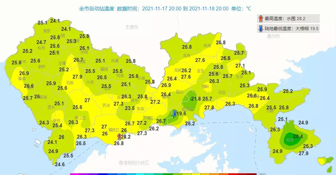
- Just look at the daytime temperature map
It's hard to realize it's autumn

△ Yesterday's daily maximum temperature map
The air conditioner (the one with snowflakes) is estimated to have been thought of
It's already November
I still have to go to work
△ Image source: Netizens contributed
(Tips: still pay attention to saving electricity)
Every time it is turned on
They ask in their minds countless times:
When will the next cold air come?
(When can I leave work?) )
Hey, isn't that coming
A stream of cold air is affecting most of the country from west to east
The minimum temperature line of 0 °C will press south to the middle and lower reaches of the Yangtze River
(Far from us)
△ Source: Central Meteorological Observatory
In the early morning of the 22nd, this cold air arrived in Shenzhen
Although it will not let us enter the winter this night
But don't underestimate it
People are "strong cold air"
Affected by it, from the early morning of the 22nd, the city will have a wind cooling process, the temperature will plummet, the average temperature will drop by 7-8 °C, the minimum temperature in the process will drop to 12-13 °C, and the maximum gusts in coastal, highland and sea areas will be about 8.
However, before that, affected by the warming of the front on the 20-21st, the temperature rose, the body felt hotter, and the wind was weaker in some times, and there may be poor visibility. Friends who have plans to go out should not forget to dress according to the body sensation and pay attention to travel safety.
△ The blue area is the area where cold air is affected
(The picture is a numerical forecast model, which has not been manually revised and is for reference only)
See here
Careful friends estimated that they found:
In the second half of this year, the more powerful cold air is "both civilized and martial"
------------------------------------
The first strong cold air arrives 2 days before the frost falls
The second strong cold air arrives 1 day after the winter
And this strong cold air is expected to arrive on the day of the snow festival
Someone has to ask:
What is the difference between the cold air this time and the last time (November 8)?
Compared with the strong cold air on the 8th of this month, the cooling amplitude of the cold air this time is quite or slightly lower, and the impact time of the wind is not so long, but because the base temperature this time is lower than the last time, and this time it is mainly "cool", the minimum temperature of the cold air process is low.
Let's scratch the point again: the weekend hasn't started cooling down yet. Don't forget to add clothes before going to work on Mondays, don't forget the temperature as long as you are graceful
Don't know how to dress?
Long sleeve base + coat combination
You deserve it
Specific forecasts
The weather was warm on the 20th and 21st, and the weather was still for some time, and there was a risk of local air pollution.
In the early morning of the 22nd, there was light rain, the temperature dropped, the body felt cool, and the maximum gust of wind along the coast, highland and sea area increased to about 8.
On the 23rd, the day turned sunny and dry, the wind weakened, and the minimum temperature on the morning of the 23rd and 24th was 12-13 ° C, and the body felt cold.
Temperatures have risen since the 25th.
Weather outlook
In the next month, the city will continue to be dry and rainy, the temperature is slightly lower, there are 2-3 cold air at the end of November, the late end of December and the late middle of December, accompanied by strong winds during the impact period, but no obvious precipitation, the minimum temperature is 10-11 °C.
Tips
1, 22 in the early morning of the temperature plummeted, morning and evening cold, everyone should add clothes in time, beware of colds and other diseases. Pay attention to ventilation when using gas water heaters, and beware of carbon monoxide poisoning.
2. The maximum gusts along the coast, highlands and sea areas will increase to about 8 levels, please reduce island tourism, sea operations and coastal activities, safety first.
3, 23 days and then turn dry weather, forest fire risk is high, we should pay attention to the safe use of fire electricity, do not bring fire into the mountains, while doing a good job of moisturizing and watering.
4. In the next month, there will be less rain in our city, please pay attention to water conservation.
Final reminder:
Cold air doesn't come until next Monday
But the lunar eclipse arrived today
The longest partial lunar eclipse in nearly 600 years will take place this evening