Strong cold air is piling up in the lower Ob River. Meteorological data show that on the morning of October 31, the northern plains of Western Siberia experienced a low temperature of nearly -25 degrees, which was already very cold during the season.
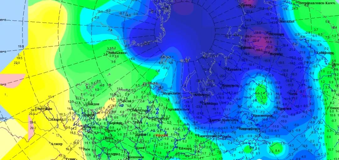
On the morning of October 31, the lowest temperature distribution in North Asia and parts of Europe came from the Russian Meteorological Service
Next, as the energy of the North American westerly wind belt spreads down, the warm ridges of Eastern Europe will rapidly rise and rise to the North Pole; under its envelopment with the Okhotsk Sea Warm Ridge, the cold air mass of Siberia has nowhere to escape, and can only accumulate and strengthen while slowly moving south, reaching the Altai Mountains - Hindu Kush around November 4.

On November 3, the situation of 500 hPa in the northern part of Eurasia, China Gas Love produced according to ECMWF data
The major supercomputer models agreed that after November 4, this huge air-conditioning mass would sweep across East and Central Asia, creating the largest cooling process since the second half of the year. The Central Meteorological Observatory also predicted early: for our country, it will be a strong cold air, stronger than the set tone before the last cold wave.
On the morning of November 4, the strong cooling zone was distributed, and Zhongqi Ai was produced based on ECMWF data
That is to say, the second cold wave in the second half of the year is likely to sweep across our country in the middle and late next week, and this trend has been largely determined. However, there are still variables about how much this cold wave will cool down and how much rain and snow it can bring.
The Extended Forecast of the Hong Kong Observatory points out that there is a trend of sharp cooling in Hong Kong from November 7-8. From HKO
The difference is that when this cold wave goes south, is it the tiger that goes down the mountain to blow away the water vapor in one breath, or slowly swallows it and gets involved with the water vapor? Judging from the current situation, when the cold wave is approaching North China, it is indeed possible to "rear-end" with the warm and humid air flow and form a cyclone. The location of this cyclone will be the key to whether it snows in the Beijing-Tianjin-Hebei Plain and whether it snows in the northernmost part of the south.
GFS mode shows that the snow from this cold wave is exactly as far north as the North China Plain. From tropicaltidibits
Regardless of whether it snows on the North China Plain and the south, it will definitely rain in the north of Xinjiang. A detachment of cold air has crept up to the upper Reaches of the Irtysh River and the lower reaches of the Ili River, stirring up large clouds of snowfall. Is this round of cold wave to be characterized by "snow"? Everyone can pay attention and be ready for intense cooling and rain and snow before next weekend.
On the evening of October 31, snow clouds approached Xinjiang. Cloud map from the Fengyun 4 meteorological satellite