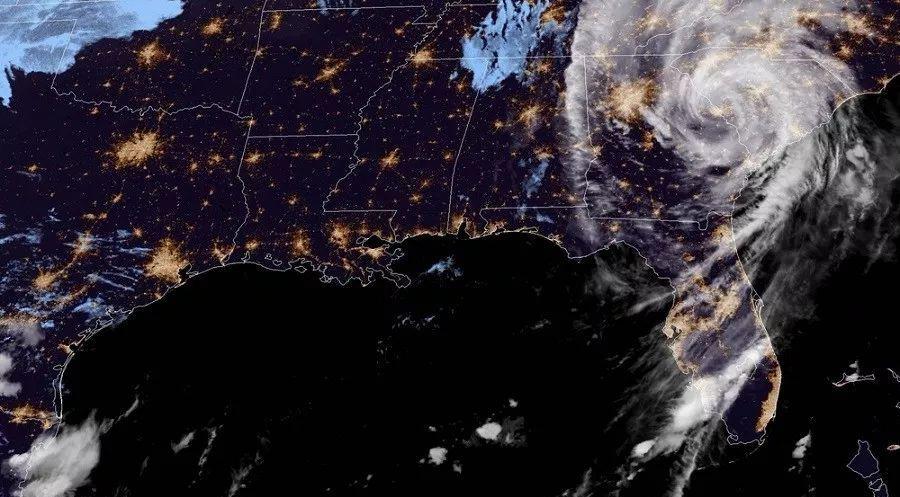
Fun Exploration News As of 16:00 Beijing time on October 11, Hurricane "Michael" continued to call the wind and rain in Georgia, but the latest forecast map from the United States Weather Service shows that tonight Hurricane "Michael" will leave the United States land and enter the warm waters of the vast Atlantic Ocean.
The latest data from the U.S. Weather Service shows that Hurricane Michael's wind speed has dropped from 63 kilometers per hour yesterday to 22 meters per second now, and the central pressure has also risen from 943 h yesterday to 983 h now. These two important indicators indicate that Hurricane Michael is no longer at its peak, the wind has been greatly reduced, and the threat to the United States has been limited.

Judging by the current wind strength of Hurricane Michael, it is only equivalent to a normal Category 8 typhoon. Unexpectedly, yesterday was still a category 4 hurricane equivalent to a super typhoon of level 17, and a day later it dropped 9 levels to become a level 8 ordinary typhoon, which was too big a gap, which was beyond the expectations of all experts.
Judging from the newly released satellite cloud map, the eye of Hurricane "Michael" that just appeared yesterday has long disappeared, its core cloud has become very scattered, and the center of Hurricane "Michael" is currently located in the 33.5N, 82.5W US territory, it is leaving the United States at a speed of 33 kilometers per hour, and in a few hours Hurricane "Michael" will enter the warm water area of the Atlantic Ocean.
Hurricane Michael, which enters the warm waters of the Atlantic, will recuperate over the vast Atlantic Ocean, continue to swallow and absorb the hot air currents nearby, and let it develop unchecked, most likely in a few days it will become a super hurricane again. But don't be afraid this time, it will never come back. For more interesting scientific exploration content, please pay attention to the only WeChat public account: Interesting Exploration
Author: Tianya